The Baltic Sea Is Europe’s Most Overlooked Power Map
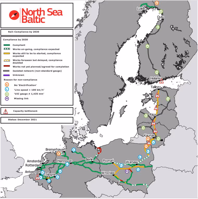
The European Commission’s North Sea–Baltic Corridor now stretches from North Sea ports through Poland and the Baltic states to Helsinki, Oulu, and Luleå, tying sea links directly to road, rail, and port infrastructure. HELCOM, the regional intergovernmental body for the Baltic marine environment, has built region-wide ship tracking from AIS data since 2005, turning the Baltic into the first sea region in the world with full real-time monitoring coverage for maritime traffic statistics.
That is why the Baltic matters more than many outsiders realize. It is not just a body of water between countries. It is the infrastructure layer beneath Northern Europe’s politics. If you want to understand how the region actually functions, you have to stop looking only at borders and start looking at connections.
The clearest place to see this is energy. Over the past several years, the Baltic Sea region has been quietly redrawing its energy geography away from Russian dependence and toward a more integrated European system. The EU’s Baltic Energy Market Interconnection Plan — BEMIP — is explicitly designed to create an open and integrated energy market among the Baltic Sea countries, and the Commission says it has already helped end the region’s old energy isolation. One major component is the Baltic Pipe, which Gaz-System describes as a strategic infrastructure project enabling gas to move directly from Norwegian fields to Denmark and Poland and onward to neighboring markets in Central and Eastern Europe. Another is the Klaipėda LNG terminal, which KN Energies says was built to reduce dependence on the former single gas supply source from the East and now contributes to energy security across the wider Baltic region.

Electricity tells the same story in even more dramatic form. Lithuania’s NordBalt link to Sweden is a 700 MW undersea and underground interconnection designed to connect the Lithuanian and Swedish transmission systems. Estonia and Finland are linked by EstLink. And in February 2025, the Baltic states completed one of the most consequential strategic shifts in the region since the end of the Cold War: ENTSO-E confirmed that Estonia, Latvia, and Lithuania had successfully synchronized with the Continental European electricity system, calling it a key milestone for energy independence, resilience, and European cooperation. This was not just a technical upgrade. It was a geopolitical uncoupling from the post-Soviet electricity architecture that had long tied the Baltics to Russia and Belarus.
And yet the Baltic’s importance is also measured by how vulnerable these links remain. On Christmas Day 2024, the EstLink 2 submarine power cable between Finland and Estonia was damaged, cutting transmission capacity between the two countries. Fingrid later said the cable had been out of service since December and only returned to commercial use in June 2025 after repairs in what it described as a “busy maritime area.” That sequence matters because it captures the new strategic reality of the Baltic Sea: energy security no longer depends only on who produces power or gas, but on whether the undersea links that connect allied economies can survive sabotage, accident, or coercion.
The same logic applies even more starkly to communications. The European Commission’s cable-security work has put the point in blunt terms: submarine data cables carry 99% of intercontinental internet traffic. In February 2025, the EU adopted an Action Plan on Cable Security; by February 2026, the Commission had gone further, introducing a Cable Security Toolbox and allocating €347 million to strategic submarine cable projects, including funds to improve repair capacity. In other words, Brussels is no longer treating undersea cables as invisible background infrastructure. It is treating them as strategic assets.
That shift did not happen in the abstract. It happened because the Baltic and nearby northern waters have become the proving ground for Europe’s new era of infrastructure anxiety. NATO’s response has been equally revealing. In January 2025, Secretary General Mark Rutte announced “Baltic Sentry,” a new NATO military activity to strengthen protection of critical infrastructure in the Baltic Sea. NATO said the mission would increase the Alliance’s military presence, improve its ability to respond to destabilizing acts, and deploy frigates, maritime patrol aircraft, naval drones, and coordinated surveillance assets, while also working with industry through its Critical Undersea Infrastructure Network. When an alliance starts treating cable protection as a military mission, it is acknowledging that the real contest is no longer only over territory. It is over systems.
Ports are the third reason the Baltic Sea is better understood as a power map than as a scenic backdrop. The Port of Gdańsk describes itself as the largest Baltic container port and says it handles 57% of Poland’s marine shipping market, with an outer port capable of receiving the world’s largest ships. Klaipėda, meanwhile, presents itself as Lithuania’s largest transport hub, where sea, land, and rail routes from east and west converge; its LNG terminal also benefits from the port’s ice-free status. Taken together, these are not peripheral outposts. They are nodes in the logistics architecture that links the Nordic and Baltic region to Central Europe and global trade.

This is also why the Baltic cannot be understood only through shipping lanes on water. It is a sea-land system. The Commission’s North Sea–Baltic Corridor includes ports, roads, rail, airports, inland waterways, and maritime links; its biggest single project is Rail Baltica, the standard-gauge line intended to connect Estonia, Latvia, and Lithuania with Poland and the rest of the EU. In February 2026, the defense ministers of Estonia, Latvia, and Lithuania also agreed to establish a joint Military Mobility Area to harmonize peacetime border crossings and transport procedures for military equipment. The point is not simply that the Baltic region is building infrastructure. It is that civilian logistics and military logistics are increasingly being designed together.
NATO’s enlargement has made the sea even more central. Finland joined the Alliance on 4 April 2023. Sweden followed on 7 March 2024. NATO’s current member list now includes every Baltic Sea littoral democracy around the basin — Denmark, Germany, Poland, Lithuania, Latvia, Estonia, Finland, and Sweden — leaving Russia as the lone Baltic littoral state outside the Alliance. That does not make the region simple; if anything, it raises the stakes. But it does change the geometry. What was once a fragmented northern space has become, from NATO’s perspective, a far more continuous strategic theater.
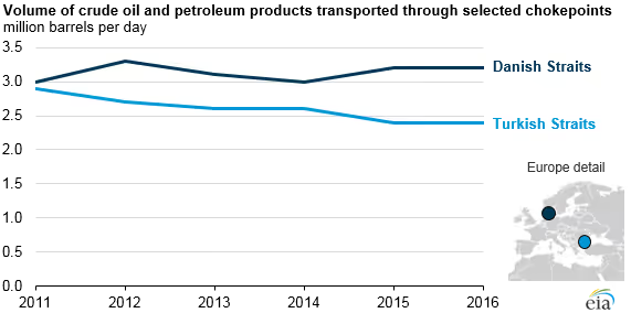
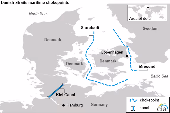
This is where the Baltic becomes especially interesting for North American readers. From Washington, Ottawa, or New York, the sea can look like a narrow regional basin at the edge of Europe. In reality, it is a concentration point where multiple forms of power overlap. Energy corridors cross it. Internet traffic depends on cables beneath it. Container flows and fuel imports move through its ports and straits. NATO’s deterrence posture now extends across nearly all of its coastline. Even the Danish Straits at the Baltic’s western exit remain, as the U.S. Energy Information Administration notes, an important route for seaborne oil exports to Europe and a chokepoint whose disruption would delay supplies and raise costs.
So the Baltic Sea is not simply part of Northern Europe’s geography. It is the mechanism through which Northern Europe now works. It reveals a region that is less defined by national borders than by corridors, interconnectors, bottlenecks, and resilience plans. It is the place where economics, climate strategy, digital dependence, and deterrence all become physical.
That is why it deserves to be read not as a margin, but as a map. And perhaps the real lesson is this: in today’s Northern Europe, the most important borders are no longer only on land. They are under water, in ports, along power lines, and across the shipping lanes of the Baltic Sea.


)%20(1).avif)